Weather Forecasting!
Idaho Falls, Idaho (KIDA) is expected to have rainfall in this forecast.
| METAR text: | KIDA 131253Z AUTO 27004KT 10SM BKN100 05/M02 A3029 RMK AO2 SLP254 T00501017 |
| Conditions at: | KIDA (IDAHO FALLS , ID, US) observed 1253 UTC 13 November 2013 |
| Temperature: | 5.0°C (41°F) |
| Dewpoint: | -1.7°C (29°F) [RH = 62%] |
| Pressure (altimeter): | 30.29 inches Hg (1025.8 mb) [Sea-level pressure: 1025.4 mb] |
| Winds: | from the W (270 degrees) at 5 MPH (4 knots; 2.1 m/s) |
| Visibility: | 10 or more miles (16+ km) |
| Ceiling: | 10000 feet AGL |
| Clouds: | broken clouds at 10000 feet AGL |
| Weather: | automated observation with no human augmentation; there may or may not be significant weather present at this time |

Above is the radar Loop

Above is the Doppler Radar
![]()
Above is the temps/winds aloft at Flight Level 100

Above is the University of Wyoming 500hPa map
Write-up
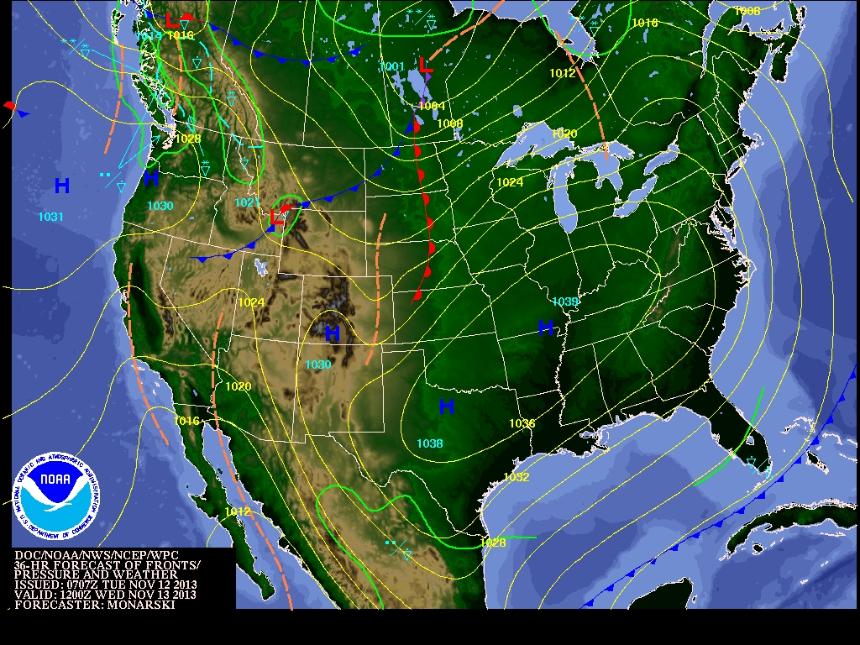
- Above you will find the weather forecast map, METAR, satellite image, Doppler Radar, temps/winds aloft map, and University of Wyoming map for Idaho Falls, Idaho (KIDA).
- Most of the maps and charts went right along with the forecast map that I first looked at. I found the satellite image and the Doppler Radar image to be the most helpful because I was really able to see the low pressure system over Idaho Falls. The METAR was good for looking at the temperature and things of that nature but it did not plainly come out and say it was raining. I found it interesting that it said there may or may not be significant weather in the area because it was not saying one way or the other. The winds and temperatures aloft chart shown is pretty hard to read but I was able to tell that there were colder temperatures and definitely a temperature change south of Idaho. The last image I posted was very hard for me to read and did not have anything posted directly over Idaho Falls. While studying aviation I have not become familiar with the last chart but I have seen all the other ones and used them for flight planning.
Relection
- I know this is the part where I am supposed to say "this is the greatest assignment I have ever had!" Well, I can't say that. However, I really did enjoy doing it because I felt like I somewhat understood many of the things in it from studying to be a pilot. I found that the forecast was pretty accurate overall and there were many different tools I could use to confirm that. I mostly used aviationweather.gov while planning flight plans, so I occasionally went to that website during this assignment to see what it said there. I found the radar loop to be very interesting because it shows how the storm formed over Idaho and got bigger and bigger. It was also cool to see part of the circulation to go counter-clockwise around the low pressure zone. This confirmed the actual forecast map from the beginning with the midlatitude cyclone. I know I just got a very short glimpse of weather planning but it made me appreciate more how much goes into weather forecasting. I can't imagine how many things a meteorologist has to look at and observe to make an accurate forecast for an area. I can honestly say this assignment was somewhat fun to do and I'm glad I chose to do it. I feel like these are things I can use in the future and definitely will when I become a professional pilot.
Above is an interesting video from NASA